Western North Carolina's waterfalls reward different kinds of travelers. One comes into view beside a highway, another lies beyond a forest hike, and a third can be appreciated from an overlook above a steep gorge. Each offers a reason to pause and pay attention to the landscape around it.
These eight waterfalls aren't a single-day itinerary or a ranking. Many are in places still recovering from severe storms, so check the managing agency's latest road and trail notices before traveling. Stay behind barriers and off wet rocks, and choose a route that suits everyone in your group.
1. Looking Glass Falls: A Roadside View Near Brevard

Looking Glass Falls is one of the easiest waterfalls on this list to see without a long hike. In Pisgah National Forest along U.S. 276, the waterfall can be viewed from a roadside overlook, with steps leading down toward another vantage point.
The Forest Service describes a drop of more than 60 feet over a rock cliff. Take time to watch from the established viewing areas rather than treating it as a photograph to collect and leave. The view changes with water level, light and the season.

Parking is along a busy road, so use care getting in and out of a vehicle and keep children close. Stairs and nearby rocks can be slippery. Check Forest Service alerts before visiting, particularly after heavy rain or freezing weather.
2. Linville Falls: A River Entering a Gorge

Linville Falls offers several perspectives on the Linville River as it narrows and drops into a rugged gorge. A walk toward the upper falls reveals one part of the landscape; other overlooks offer a broader view when the relevant trails are open.
Trail conditions here require particular attention. As of November 13, 2026, the National Park Service lists the upper-falls trail as open with specified access and the trail from the plunge basin to the overlook and base as closed. Some parkway-area facilities remain closed after Hurricane Helene. Check the current trail and road status rather than relying on an old itinerary.

The terrain ranges from moderate to strenuous, and climbing on rocks or swimming in the Linville River is prohibited. Allow time for elevation changes and return before dark. The most memorable view is the one you can enjoy from a safe, permitted overlook.
3. Crabtree Falls: A Forest Hike With a Cascade at the Bottom
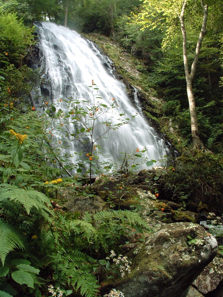
Crabtree Falls is a destination for visitors who enjoy a substantial walk through the woods as much as the waterfall itself. The National Park Service describes a route that descends through mixed forest toward a cascade over a rock face, then offers a longer climb back toward the starting area.
Expect uneven footing and a meaningful ascent on the return. Give yourself time, carry water and wear footwear appropriate for rocky terrain. The wet rocks around the falls are slippery; the park asks visitors not to climb them.

As of November 13, 2026, the parkway road-status page lists the Crabtree Falls trail as open with some walking-bridge closures, while the campground is closed. Other agency pages have displayed different status information, so check the latest park alerts and contact the park if the route is unclear before making the trip.
4. Upper Whitewater Falls: Big Views From Established Overlooks

Upper Whitewater Falls drops down the Blue Ridge Escarpment in a dramatic series of cascades. The Forest Service recommends two established viewpoints, which allow visitors to appreciate the scale of the falls without approaching the dangerous cliffs and water.
A paved walkway leads from the parking area to the upper overlook; the agency describes that route as wheelchair accessible. A lower overlook requires a long staircase. Check current conditions, facilities and fees before visiting, and decide which viewpoint works for your group.

The agency warns that people have been seriously injured or killed after leaving the trail here. Stay behind guardrails and do not wade or walk on rocks in or above the waterfall. A distant view from the overlook is the intended experience.
5. Dry Falls: A Waterfall You Can Walk Behind

Near Highlands, Dry Falls offers a distinctive perspective: an established path leads toward the space behind the falling water. Despite the name, spray and weather can make the area damp, so bring a layer and expect slippery footing.
The Forest Service describes steps on the route from the parking area to the path behind the falls. Visitors who prefer fewer steps should check current accessibility and overlook information before traveling. Never cross barriers or climb beyond the maintained route for a closer view.

This stop can be paired with a relaxed visit to Highlands or another nearby attraction, but mountain roads take time and conditions can change. Verify road access and allow for busy parking on popular weekends.
6. Rainbow Falls: A Hike From Gorges State Park

Rainbow Falls is reached by a trail beginning in the Grassy Ridge area of Gorges State Park and continuing onto neighboring national forest land. The park's map describes the Rainbow Falls Trail as strenuous and approximately 1.5 miles one way, so plan for the return as well as the descent.
Carry water, check the forecast and be prepared for uneven, steep sections. A visitor center stop can help orient your group to the current trail map and conditions. Leave enough daylight to complete the return without rushing.
Waterfall areas are hazardous even when they appear calm. Stay on the marked trail, respect closures and avoid rocks near the edge. Gorges State Park also asks visitors to be bear aware and secure food and trash.
7. High Falls: Granite and the Little River

In DuPont State Recreational Forest, High Falls spreads over a broad granite slope on the Little River. The Friends of DuPont Forest describes an overlook reached from the High Falls access area, making this a good choice for a visit focused on the water and surrounding forest.
Review the forest map before setting out; several routes connect access areas and overlooks, and some are shared with other trail users. Bring water, pack out your trash and give horses and bicycles appropriate space where routes are shared.

Visitors are prohibited from climbing on rocks or wading above waterfalls in the forest. Follow signs and stay within the permitted viewing areas. The nearby covered bridge is another interesting feature, but the river above the falls is not a place to enter the water.
8. Hooker Falls: A Shorter Walk to the Little River

Hooker Falls is a wide, relatively low waterfall in DuPont State Recreational Forest. From the Hooker Falls access area, a short walk leads toward the falls, making it an appealing option for a shorter outing when the area is open and parking is available.
The access area is popular, especially during warm weather, and parking is first come, first served. Restrooms are at the parking area; bring what you need for the walk and carry out your trash. The Hooker Falls Trail is not open to bikes or horses according to Friends of DuPont Forest.

Water below a waterfall can still be unpredictable. Non-swimmers should use extreme caution, and no one should wade above the falls. Check the forest's latest rules and conditions and keep dogs leashed.
Before You Go
Check the National Park Service, U.S. Forest Service, state park and forest notices for closures, weather and route changes. Storm damage, ice, high water and falling trees can make familiar routes unsafe. Stay on signed trails, avoid waterfall edges and wet rocks, and never cross a closed barrier.


