Wisconsin's Great Lakes coast is more varied than a single beach day can suggest. Lake Superior meets sandstone cliffs and islands in the north; Lake Michigan borders dunes, lighthouses and the wooded Door Peninsula farther east. At each stop, the water sets the pace, whether it is glassy and blue or sending waves against the shore.
These eight destinations are spread across two lakes and many miles. Choose a region for your trip, check weather and current access, and leave room to stop between the major attractions. Great Lakes conditions can change quickly, even on a sunny day.
1. Apostle Islands Mainland: Sandstone Above Lake Superior
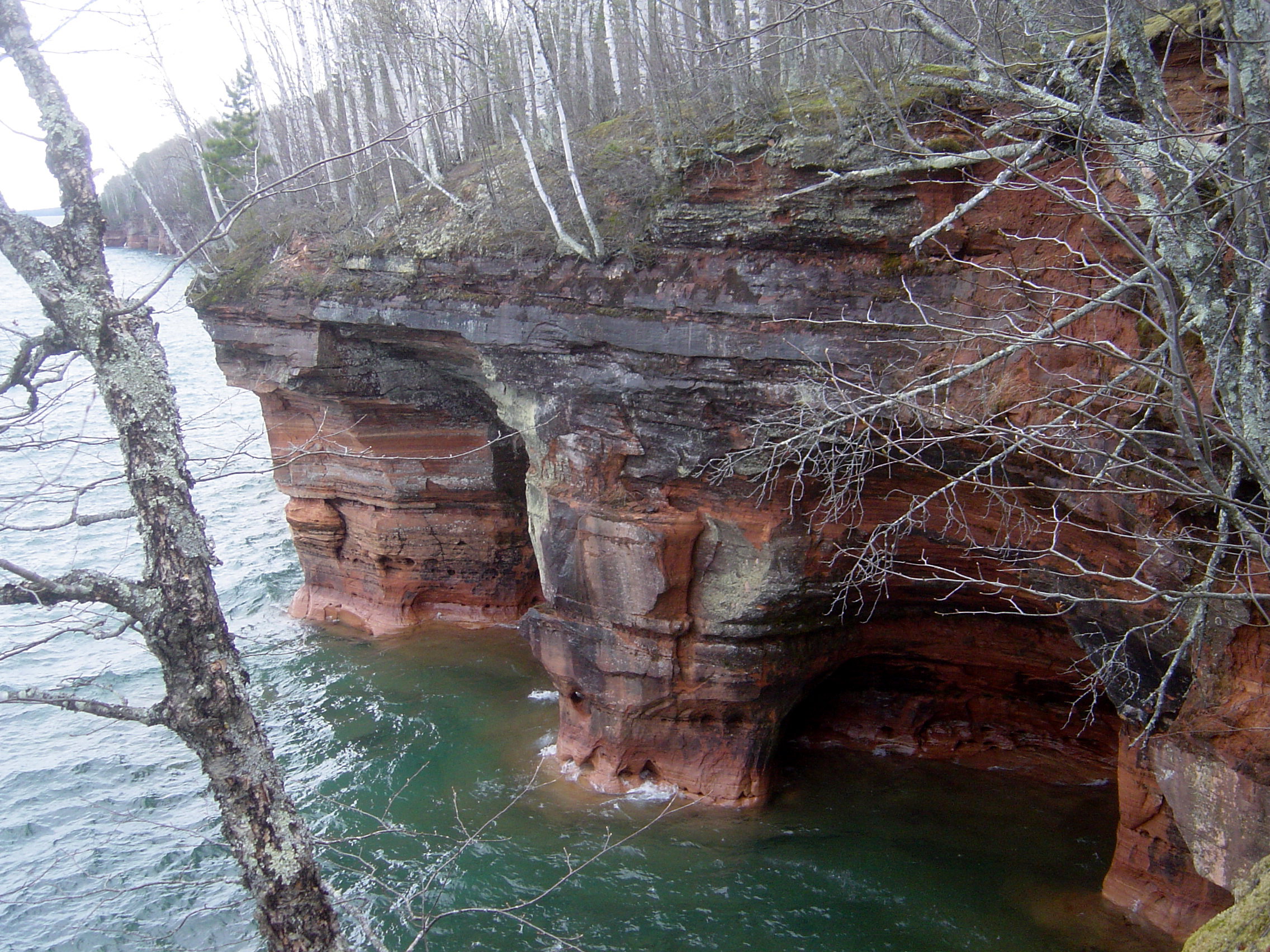
Near Meyers Beach, the mainland section of Apostle Islands National Lakeshore offers a way to experience Lake Superior without crossing to an island. The Lakeshore Trail travels through forest and along sandstone cliffs, where views reveal some of the shapes water and weather have carved into the shore.
This is a rugged hike, not a short paved overlook. The National Park Service describes ravines, roots, steep sections and slippery footing; its trail guide puts the first crevasse about 1.8 miles from the trailhead. Allow time for the return, carry water and stay well back from unstable cliff edges.

Sea caves are best seen by boat, but the lake's cold water and changing waves demand skill and proper equipment. Consider an authorized guided trip and follow current marine forecasts. In winter, the ice caves are closed unless the park superintendent declares them open; do not assume ice is safe.
2. Big Bay State Park: An Island Shoreline With a Boardwalk

Big Bay State Park occupies part of Madeline Island, where sandstone bluffs, forest and a sandy shore meet Lake Superior. The island belongs to the Apostle Islands archipelago, though it is outside the national lakeshore's boundaries, so it makes a distinct stop with its own state park facilities.
The Wisconsin DNR describes an accessible Boardwalk Trail along the sand spit, with benches, signs and lake views. Other trails follow the shoreline and travel through the woods. Choose a route that suits your group and check the current map; pets are not permitted on the boardwalk.
Most visitors reach Madeline Island on the ferry between Bayfield and La Pointe. Schedules and service can change with weather and ice, particularly in winter, so confirm the crossing before making plans. A Wisconsin state park vehicle admission sticker is required at Big Bay.
3. Peninsula State Park: A High View Over Green Bay

Peninsula State Park on the Door Peninsula combines forest, shoreline and views across the waters of Green Bay. Eagle Tower provides one of its most expansive perspectives, with the surrounding islands, shoreline and village of Ephraim visible from above.
Visitors can climb the stairs or use the 850-foot accessible canopy walk to reach the observation deck. The tower operates seasonally and is generally closed in the middle of winter because frost and snow make surfaces slippery. Check the DNR's current tower information before making it the focus of a visit.

For a ground-level outing, the park offers trails of different difficulty, including the rocky Eagle Trail and easier woodland routes. Parking, camping and facilities can be busy in peak season. Bring a map and allow time for a shoreline stop as well as the view from above.
4. Cave Point: Waves Against Door County's Rock Ledges

Cave Point County Park is a small park with an outsized view. Lake Michigan meets wave-worn rock ledges along the eastern side of the Door Peninsula, and the scene can change dramatically with the wind. On a calm day the water reveals the shape of the shoreline; on a rough day the waves become the spectacle.
The county park offers picnic space and a short shoreline trail, and it borders Whitefish Dunes State Park. A trail connection links the areas, but closures can interrupt that walk, so consult both parks' current notices rather than assuming the whole route is open.

Stay well back from cliff edges and breaking waves. Wet or icy stone is slippery, and the water below can be cold and turbulent. If you plan to paddle, choose an operator and conditions appropriate to your experience; watching from established public areas can be a rewarding visit on its own.
5. Whitefish Dunes: A Beach Protected by Fragile Dunes

At Whitefish Dunes State Park, the lakefront is only part of the landscape. Behind the sandy shore are dunes, forest and trails that reveal how plants help hold this delicate environment together. The park's nature center is a useful place to begin learning about what you are seeing.
Walk on the beach or follow designated trails and stairs rather than climbing over dune vegetation. The DNR describes several routes, including a trail toward Old Baldy, the park's tallest dune. Check the park's current notices before choosing a route; trail maintenance and erosion can change access.

The first beach access point is no longer accessible to all mobility devices because of shoreline erosion, according to the DNR. Ask the park about current conditions and alternatives for your group. A state park vehicle admission sticker is required.
6. Newport State Park: Shoreline Walks and Dark Skies

Near the end of the Door Peninsula, Newport State Park offers a quieter mix of forest, Lake Michigan shore and backpack campsites. Its protected night sky is another reason to linger, turning a daytime shoreline visit into an opportunity to watch for stars after sunset.
The Wisconsin DNR recommends becoming familiar with viewing areas during daylight. Check the park's current hours and any construction notices, bring a light that helps preserve night vision and stay on established paths. Weather, moonlight and clouds all affect what you can see.

During the day, trails follow stretches of shore and lead through forest. Backpack sites require planning and reservations where applicable. Carry what you need, protect the quiet setting and check current trail or campsite conditions after storms.
7. Point Beach: Forest, Sand and a Lighthouse View

Point Beach State Forest near Two Rivers stretches along Lake Michigan, with sandy shoreline backed by pine and hemlock forest. Visitors can make this a relaxed beach outing, a longer walk or bike ride, or a stop centered on maritime history.
Rawley Point Lighthouse is a distinctive steel tower maintained as an aid to navigation. The DNR says it can be viewed from the beach, but tours normally are not available. The nature center interprets the lighthouse, local ecosystems and shipwrecks when it is open.

Check seasonal facility hours and beach conditions before visiting. The forest provides beach access mats at some locations during summer and has an all-terrain wheelchair available by arrangement; contact the property for current availability. A state admission sticker is required.
8. Kohler-Andrae: A Cordwalk Through the Dunes

South of Sheboygan, Kohler-Andrae State Park is known for its Lake Michigan beach and dunes. The Dunes Cordwalk follows the shore through a landscape of sand, wetlands and pine, helping visitors see the dunes while reducing damage to the plants that hold them together.
The DNR describes the cordwalk as a moderate to difficult hike. For a shorter or more accessible alternative, the Black River Marsh Boardwalk offers a look at wetland plants and birds. Use the park's map to select the route that fits your group's abilities and available time.

Weekends and holidays can bring busy parking lots, especially in warmer months, so consider arriving early or visiting at a quieter time. Stay on marked routes in the dunes, check beach conditions and remember that Lake Michigan's temperature and waves may be very different from the weather on shore.
Before You Go
Check current park alerts, weather, ferry schedules, admission requirements and beach advisories before traveling. The two lakes are cold and powerful bodies of water: avoid exposed ledges in rough conditions, give wildlife space and respect closures designed to protect visitors and fragile habitat.


