California can take you from a coastal redwood grove to a high desert townsite, then down to a bay framed by granite and blue water. These eight destinations in the state park system offer very different ways to experience that variety, whether you have a few hours for a scenic walk or are planning a longer trip.
They are spread across a large state, so consider them ideas for several journeys rather than one ambitious itinerary. Check the park's current alerts and road conditions before leaving: wildfire recovery, storms, winter snow and seasonal access can change the plan.
1. Prairie Creek Redwoods: Forest, Ferns and a Wild Coast

Prairie Creek Redwoods State Park protects a landscape where coast redwoods meet open prairie and the Pacific shore. Walk among the tall trees and the scale becomes personal: the forest floor, ferns and filtered light invite a slower pace than a highway drive can offer.
The park is managed cooperatively with Redwood National and State Parks. Gold Bluffs Beach and the Fern Canyon trailhead are popular side trips, but the park requires permits for the day-use area during part of the year. Roads can also close for weather, so check the status of Newton B. Drury Parkway before visiting.

Start with current park information and choose a route that matches the time and conditions. Give elk and other wildlife plenty of space, remain on established paths and remember that streams and muddy surfaces can make a short-looking walk more demanding.
2. Humboldt Redwoods: An Avenue Through the Giants

The Avenue of the Giants follows the river corridor through Humboldt Redwoods State Park, offering a memorable way to enter redwood country. Yet the most rewarding part may be leaving the car in a designated area and walking quietly into a grove.
Founders Grove preserves old-growth coast redwoods and tells a story about the people who organized to protect these forests. The park's map shows other groves and trails along the avenue, making it possible to choose a short stop or make a more leisurely day of the drive.

Check the latest park map for open trailheads, parking and facilities. Redwoods are living ecosystems, not just impressive measurements: protect their roots by staying on paths and leave plants and fallen wood in place. Flooding and winter storms can alter access.
3. Point Lobos: Cypress Groves and a Rugged Shore

South of Carmel, Point Lobos State Natural Reserve pairs coastal overlooks with Monterey pine, cypress and coves. A short walk can offer views of water, rock and wildlife without requiring a long expedition into the backcountry.
The state identifies accessible portions of several routes, including Cypress Grove and Sea Lion Point, though individual surfaces and grades vary. Whalers Cove adds a different viewpoint and a connection to the area's maritime past. Bring binoculars and observe seals and other wildlife from a respectful distance.

This is a protected reserve with rules that differ from a typical beach park; pets are restricted, and collecting natural materials is not allowed. Parking can fill, and official listings have shown differing open/closed status, so confirm directly with the reserve before setting out.
4. Pfeiffer Big Sur: A Forest Stop Along Highway 1

Pfeiffer Big Sur State Park gives travelers a chance to leave the highway for redwood groves, river scenery and trails in the Big Sur valley. Its forest setting makes a useful contrast to the exposed coastline that many visitors associate with the region.
The park reopened some day-use areas, camping and selected routes in October 2026 after the Timber Fire. Other trails remained closed for assessment and recovery. Do not assume a favorite route is open simply because the park itself has reopened.

Review the Monterey District's latest notices and Caltrans road conditions before driving. Recovery work and storms can affect both parks and Highway 1. Follow all barriers and staff instructions, and consider a short open trail or the visitor facilities when longer routes are unavailable.
5. Emerald Bay: A Tahoe View With a Steep Walk to Shore

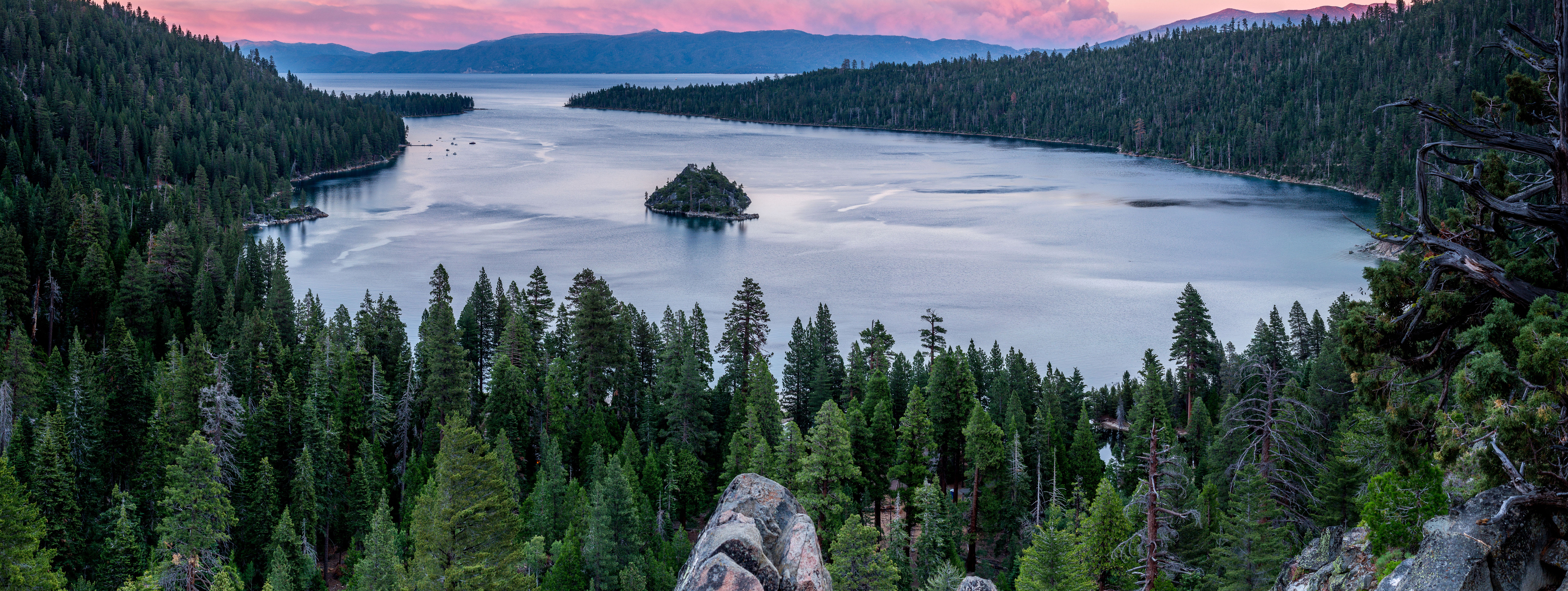
Emerald Bay State Park offers one of Lake Tahoe's memorable panoramas: blue-green water, granite slopes and Fannette Island framed by the mountains. The view from above is an attraction in itself, but the shoreline offers another perspective for visitors prepared for the descent.
Vikingsholm, the Scandinavian-inspired historic house beside the bay, is reached by a steep route of roughly two miles round trip from the overlook parking area. The return climbs hundreds of feet at altitude. The state says the trail is not wheelchair accessible, so check its accessibility information and any special arrangements before visiting.
House tours and campgrounds operate seasonally. Parking is limited and vehicles cannot drive down to the lake. Snow and ice make the route especially demanding in winter; carry water, wear appropriate footwear and turn back if conditions exceed your ability.
6. Bodie: A Mining Town Preserved in Arrested Decay

At Bodie State Historic Park, weathered buildings stand in a high desert landscape east of the Sierra Nevada. The former gold-mining town is maintained in a state the park calls “arrested decay”: preservation work stabilizes structures without making the town look newly built.
Walk the streets and look through windows where permitted to get a sense of the town's surviving buildings. The state reminds visitors that the townsite is only part of a much larger mining landscape, which includes physical evidence of extraction and processing over many decades.

Bodie is remote, above 8,000 feet, and has no regular food or fuel services. Bring supplies, check the road and weather, and observe the park's hours. A portion of the usual road is unpaved; snow may change or prevent vehicle access. Leave every object where you find it.
7. Anza-Borrego Desert: Canyons, Washes and Wide Open Space

Anza-Borrego Desert State Park offers a large, varied Colorado Desert landscape of washes, canyons and mountains. A stop at the visitor center in Borrego Springs is a useful first step: staff and maps can help match a route to your vehicle, weather and experience.
Borrego Palm Canyon is one of the park's familiar walks, but visitors should check the latest trail notice. The state hiking page reports that the palm grove itself is closed while the trail leads toward an overlook of the grove's recovery. Do not enter a closed area to reach a photograph you may have seen online.

Desert heat can be dangerous, particularly in summer. Carry and drink plenty of water, use sun protection, tell someone your plans and avoid the hottest part of the day. Some routes require high-clearance or four-wheel-drive vehicles; ask about conditions before leaving paved roads.
8. Crystal Cove: A Coastal Park With a Historic District

Crystal Cove State Park combines beaches, coastal bluffs and inland trails between Newport Beach and Laguna Beach. Its historic district adds a different layer to the landscape, with coastal cottages that speak to earlier beach-community life.
For a shorter outing, California State Parks identifies the paved Bluff Top Multi-Use Trail as an accessible route along the coast. Other trails lead inland, where the terrain and exposure can make the experience feel quite different from the beach. Pick a route after checking the park map and current conditions.

Recent high surf caused closures and damage in portions of the historic district, so confirm what is open before planning a beach or cottage visit. Use designated access points, obey barriers and watch the ocean from a safe distance when waves are high.
Before You Go
California's distances and conditions are easy to underestimate. Verify road status, park alerts, permits, parking and seasonal services with the responsible agency. Bring water and layers, respect wildlife and cultural sites, and be prepared to change plans for heat, snow, fire or coastal storms.