Some Tennessee waterfalls announce themselves from a high overlook. Others ask for a forest walk, a trip into a sandstone gorge or a little patience with changing water levels. Together they show how much variety can fit into one state's landscape.
These seven stops range from a short walk near a Smokies visitor center to more demanding trails on the Cumberland Plateau. They are separate trip ideas, not a single-day itinerary. Conditions, access and water levels can change quickly; check with each park before setting out and choose a route that fits everyone in your group.
1. Fall Creek Falls: A Big View From the Plateau

Fall Creek Falls drops into a forested gorge in the state park that shares its name. The high overlook gives visitors a dramatic sense of the plateau's scale without requiring everyone to attempt the steep descent toward the bottom.
If you want a longer outing, the park has a network of trails and other cascades, but check current maps and closures before choosing a route. Storm damage has affected some trails in the park, and a route described in an older guide may not be available. The descent to the base is steep and requires a climb back out.

Give yourself time to look beyond the main waterfall. The surrounding forest, rock and gorge are part of the experience. Stay behind barriers, wear shoes with good traction and avoid cliff edges even when the path looks dry.
2. Burgess Falls: A River's Series of Drops
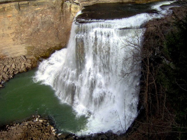
At Burgess Falls State Park, the Falling Water River makes a succession of drops through a rugged landscape. The final waterfall fans across the rock and into a gorge, but the smaller cascades along the way also deserve a pause.
The park's riverside route leads toward a main overlook. Trail surfaces include uneven ground and steep sections, so allow more time than a map's mileage alone might suggest. The gorge and old route down to the base have had closures; enjoy the view from open, signed areas and check current park guidance rather than assuming a descent is possible.

The water's appearance changes with recent rainfall. More flow can make a striking scene but also creates more hazardous conditions near the river. Keep children close, remain on the trail and never cross barriers for a photograph.
3. Cummins Falls: Choose Between an Overlook and a Gorge Adventure

Cummins Falls near Cookeville offers two very different ways to experience the same place. An overlook lets visitors see the waterfall from above, while access to its base involves a demanding trip into the gorge.
The state tourism office describes an accessible overlook reached by the Falls Overlook Trail. Check the park's latest accessibility details and trail conditions before visiting; a short route is not necessarily suitable for every visitor or mobility device.

To reach the base, a gorge access permit is required, and a permit does not override weather closures. The park warns that the route can require wading or swimming, scrambling and crossing slippery rocks, and that rain upstream can trigger rapid rises even when it is dry at the park. Ask staff about the day's conditions and turn back when access is closed or water rises.
4. Twin Falls: Water Emerging From a Rock Wall

Twin Falls at Rock Island State Park has a distinctive appearance: water pours from the rock face above the Caney Fork, making the gorge feel like a wall of streams. Depending on water levels and operations upstream, the scene can look different from one visit to the next.
The state park identifies an overlook near the parking area as one way to see the falls. Check the park map to find the right access point and review current trail or gorge closures before traveling. An overlook visit and a descent to the river are very different outings.

Water can rise rapidly in the gorge when TVA operations change. The park warns visitors to leave immediately if water rises or warning sirens sound, and swimming and wading are prohibited in the Twin Falls area because of dangerous currents. Observe all signs and enjoy the falls from permitted viewpoints.
5. Greeter Falls: A Savage Gulf Detour

In Savage Gulf State Park, Greeter Falls moves over an upper ledge before dropping into a lower plunge pool. The waterfall sits in a broader landscape of sandstone cliffs and wooded ravines, giving hikers a reason to look up at the gorge walls as well as down at the water.
Use the Savage Gulf West trailhead for the Greeter Falls area and obtain a current map before starting. The route has steep, rocky portions and stairs, and the friends group describes its longer day loop as moderate to strenuous. Different routes in the park lead to different destinations; pick one for your available time and experience.

Wet rock can be extremely slick. Stay on maintained routes, carry water and avoid cliff edges and waterfall jumping. Flows vary with season and rainfall, so even a familiar trail can feel different after a storm.
6. Foster Falls: A View From the Rim and a Trail Below

Foster Falls drops from the Cumberland Plateau near Sequatchie. The falls are part of Fiery Gizzard State Park, formerly managed as part of South Cumberland; older maps and signs may use the previous park name.
A short route leads from the parking area toward an overlook. A separate trail descends toward the base, where the terrain is steep and rocky. The waterfall also marks the southern end of the much longer Fiery Gizzard Trail, so don't mistake a short visit to the overlook for preparation for the full backcountry route.
Check current park conditions and carry enough water for your chosen hike. Keep clear of the edge, use the designated trail and remember that going down is only half the effort. If conditions are wet or anyone in your group is uncomfortable on rough ground, enjoy the view from an open overlook instead.
7. Cataract Falls: A Smokies Walk Near Sugarlands

Cataract Falls provides a quieter change of pace near the Sugarlands Visitor Center in Great Smoky Mountains National Park. The National Park Service describes a roughly 0.7-mile round trip through the woods to this narrow cascade, which can be especially noticeable after rain.
The route follows Fighting Creek before turning toward the falls. Ask at the visitor center for a current map, parking information and trail conditions. The park also provides information about adaptive equipment for this trail area; contact the park for the details needed to decide whether the route suits your group.

The park warns that visitors have been seriously injured climbing around Cataract Falls. Take pictures from the trail and lower viewing area, and leave the wet rocks alone. If you are also considering Laurel Falls, check the national park's closure page: that trail is closed for rehabilitation.
Before You Go
Check official alerts, weather and trail maps shortly before leaving. Rain upstream can change water levels without warning, and waterfalls are not safe places to climb or jump. Stay on open routes, keep back from cliff edges, carry drinking water and let someone know your plans. Parking rules and permits vary by park.