Minnesota's lakes are famous for good reason, but the state park map also leads to prairie, deep underground passages and rocky river gorges. You can stand near the beginning of the Mississippi River, look for bison across tallgrass prairie or trace the work of an ancient glacial river in stone.
These seven parks are spread across Minnesota and make separate trip ideas rather than one short route. Tours, roads and trail conditions change with the season, so check current park information before leaving. A state park vehicle permit is required at many sites; verify the rules for your destination.
1. Itasca: Where the Mississippi Begins

At Itasca State Park, Lake Itasca narrows into the beginning of the Mississippi River. The water is small enough here that visitors can stand beside its source and imagine the much larger river it will become on its journey south.
The Minnesota Department of Natural Resources notes that Ojibwe guide Ozawindib led Henry Rowe Schoolcraft to the source in 1832, a reminder that the landscape and the people who knew it long predate the familiar historic marker. Follow the boardwalk and paths near the headwaters to see the river and surrounding vegetation from different angles.

The headwaters area has an accessible loop with a mix of surfaces; check the park map and current conditions for your needs. Itasca also protects old-growth pine forest, so consider leaving time for a second walk or a drive through the park. Water levels and slippery rocks can change the experience at the river's edge.
2. Blue Mounds: Prairie, Pink Rock and Bison

In southwestern Minnesota, Blue Mounds State Park protects prairie beneath striking Sioux quartzite cliffs. The rock can look pink or purple up close, while the broad grassland gives visitors a sense of a landscape that once covered a much larger part of the region.
The park is home to a conservation herd of bison. DNR recommends looking from the observation deck or trails outside the enclosure; the animals roam a large range and may not be visible. Seasonal naturalist-led prairie and bison tours offer another possible way to learn about the herd, with reservations and age requirements.

Never enter the bison enclosure or approach the animals. Check tour availability before traveling, stay on marked paths and bring water and sun protection for an exposed prairie walk. The park's quarry and cliff trails also offer opportunities to learn about its geology without centering the whole visit on wildlife sightings.
3. Minneopa: A Waterfall, a Mill and a Bison Drive

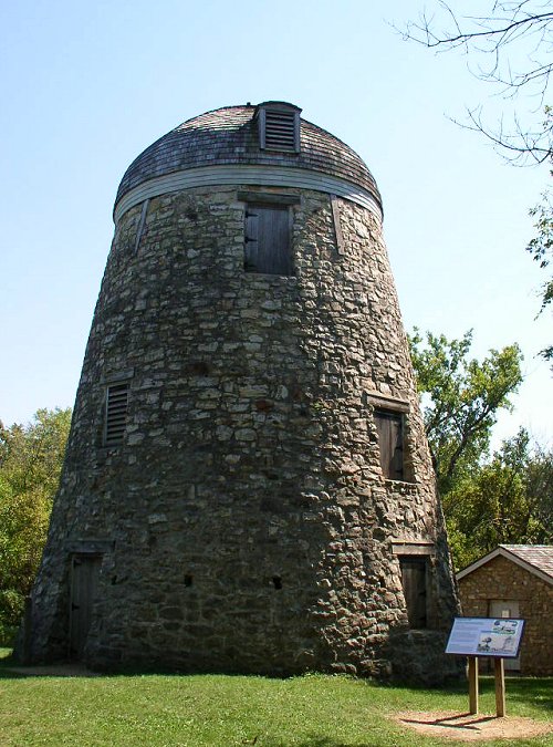
Near Mankato, Minneopa State Park has two distinct areas worth understanding before you arrive. One includes Minneopa Creek and its double waterfall; the other contains prairie, the historic Seppmann Mill and a bison range.
The falls can be viewed from the established overlook area, while trails into the gorge involve steep steps and may be closed when conditions or maintenance require. Check current park alerts rather than relying on an older trail description. The name Minneopa comes from Dakota and is interpreted by the DNR as "water falling twice."
On the bison side, visitors can drive their own vehicles through the range when the road is open. Stay inside the vehicle, give the bison space and follow all posted instructions. The DNR says Bison Drive Road closes on Wednesdays for maintenance; conditions and hours can also change, so check before your visit.
4. Interstate: Ancient Potholes on the St. Croix

At Minnesota's Interstate State Park in Taylors Falls, rounded holes in the dark rock tell a story far older than the highway potholes most of us know. Powerful water associated with glacial melt helped scour the formations along the St. Croix River.
The DNR's interpretive material explains how sand and rock spun in turbulent water and carved into the basalt. Paths and viewing areas give visitors a chance to examine several formations while also taking in the river gorge. Stay behind railings and watch your footing: rock surfaces can be uneven and slippery.

The river forms the state boundary here, and there is also a Wisconsin Interstate State Park across the water. The two parks have separate vehicle-permit systems. If you plan to visit both sides, check each state's current rules and allow time for the crossing and additional exploring.
5. Whitewater: Bluff Country Along a Spring-Fed River

Whitewater State Park in southeastern Minnesota follows a river through a landscape of wooded bluffs and valleys. It offers a different kind of Minnesota scenery from the prairie in the southwest or the rocky North Shore of Lake Superior.
The DNR highlights hiking, trout fishing, camping and the Chimney Rock Trail, which climbs toward a bluff view over the Whitewater River. Review the map and your group's ability before choosing a route: a dramatic overlook can involve steep sections, and conditions after rain may make footing more difficult.

The river corridor also makes a good setting for a slower visit. Bring a picnic, look for seasonal programs or spend time near the designated beach when conditions allow. Check fishing regulations and any licenses or reservations you need, and stay back from bluff edges.
6. Lake Vermilion-Soudan: A Journey Into Iron-Mining History

Lake Vermilion-Soudan Underground Mine State Park combines lake country with the history of Minnesota's first underground iron ore mine. Above ground, historic buildings and trails help explain a working landscape that is very different from a typical beach or campground visit.
Guided tours can take visitors deep underground when they are operating. The DNR says the mine reopened for tours after flooding in 2024 prompted cleanup and repairs. Tour schedules, reservations, physical requirements and availability can change, so consult the current park and tour pages before making a long drive.

If an underground trip isn't suitable or tickets are unavailable, ask about surface exhibits and open trails, or explore the Lake Vermilion side of the park. Dress for the conditions described by the operator and follow staff guidance in this historic industrial site.
7. Forestville/Mystery Cave: A Landscape Shaped From Below

In southeastern Minnesota, Forestville/Mystery Cave State Park brings together wooded valleys, streams and an underground world. The DNR identifies Mystery Cave as Minnesota's longest cave, with more than 13 miles of passages, though a public tour visits only selected parts.
Guided tours interpret formations and pools created over long periods as water moved through the bedrock. Different tour options have different physical demands and schedules; check the DNR's current accessibility information, age requirements and reservations before choosing one. Wear the clothing and footwear the operator recommends.

Above ground, the park offers trails, camping and streams as well. The DNR cautions that phone GPS directions to the cave can be unreliable and that cell service in the park is limited. Save directions ahead of time and confirm which entrance serves your planned activity.
Before You Go
Check current alerts, vehicle-permit requirements, tour schedules and weather before leaving. Trails may close after storms or become icy or muddy; give wildlife plenty of space and remain on designated routes. For cave and mine visits, consult the operator about accessibility, reservations and clothing before booking.